

Danger Signs
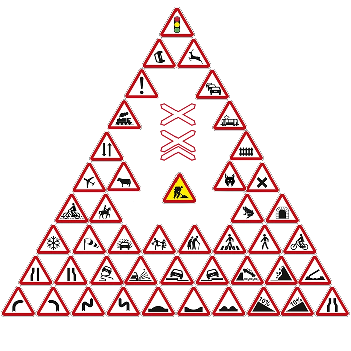
Danger Signs
Hazard signs indicate the existence or possibility of the emergence of particularly dangerous traffic conditions that require special attention and caution on the part of the driver.
Hazard signs must not be placed less than 150 metres or more than 300 metres from the point of the road to which they refer, unless local conditions do not permit; in this case, an additional distance indicator panel should be used. When you encounter any of these signs, you should drive at a particularly moderate speed.
|
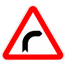
A1a - Turn right
Indication of the existence of a dangerous right turn. |
|
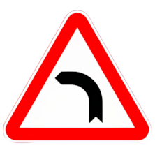
A1b - Left turn
Indication of the existence of a dangerous left turn. |
|
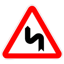
A1c - Right turn and counter-curve
Indication of the proximity of a succession of dangerous curves, the first being on the right. |
|
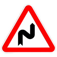
A1d - Left turn and counter-curve
Indication of the proximity of a succession of dangerous curves, the first being on the left. |
|
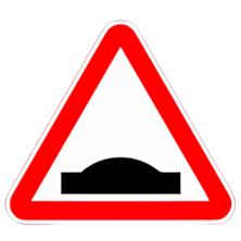
A2a - Bump
Indication of a section of track or bridge with convex deformation in the pavement. |
|
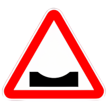
A2b - Depression
Indication of a section of track or bridge with concave deformation in the pavement. |
|
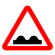
A2c - Bump or depression
Indication of road or section of track where there is marked deformation of the pavement. |
|
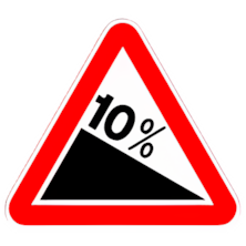
A3a - Dangerous descent
Indication of a steep slope or that, for any other reason, constitutes a danger to traffic. In the inscription, the slope of the descent is indicated in percentage. |
|
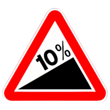
A3b - Steep Slope Climb
Indication of a steep slope climb; In inscription, the slope of the climb is indicated in percentage. |
|
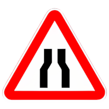
A4a - Narrow passage
Indication of a narrowing of the road, with the constant configuration of the signal. |
|
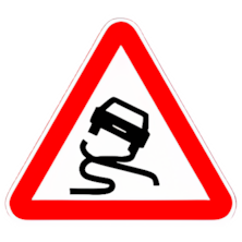
A5 - Slippery floor
Indication of a section of track whose pavement may become slippery under certain conditions. |
|
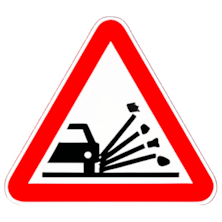
A6 - Gravel Projection
Indication of the proximity of a section of track where there is a risk of gravel projection. |
|
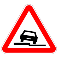
A7a - Low berms
Indication of a section of track with low verges on the right-hand side. |
|
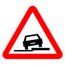
A7b - Low berms
Indication of a section of track with low shoulders on the left side. |
|
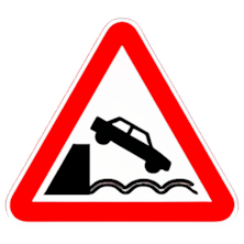
A8 - Exit at a pier or precipice
Indication that the road flanks or ends at a pier or precipice. |
|
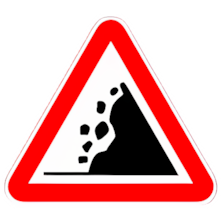
A9 - Falling rocks
Indication of the proximity of a place where there is a danger of falling stones. |

|
A10 - Mobile bridge
Indication of the proximity of a location where there is a movable bridge that, when raised, temporarily interrupts traffic. |
|
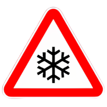
A11 - Snow or ice
Indication of a section of road where the pavement may become slippery due to the possibility of snow or ice. |
|
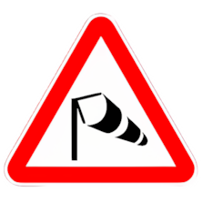
A12 - Crosswind
Indication of the proximity of a section of road where very strong side winds are common; the orientation of the symbol shown indicates the predominant direction of the wind. |
|
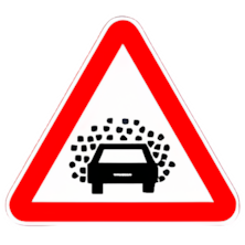
A13 - Insufficient visibility
Indication of the proximity of a section of public road where there may be meteorological or environmental conditions that make visibility insufficient, particularly in the event of fog, heavy rain, snowfall or clouds of smoke or dust. |
|
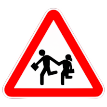
A14 - Children
Indication of a place frequented by children, such as a school, playground or similar. |
|
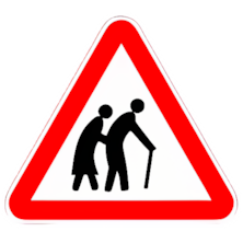
A15 - Elderly
Indication of a place frequented by elderly people, such as a home, garden, park or similar place. |
|
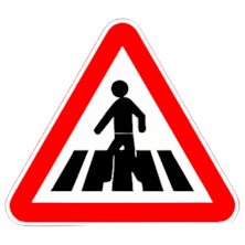
A16A - Passage for Pedestrian crossing
Indication of approaching a pedestrian crossing. |
|
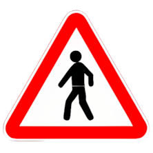
A16B - Pedestrian Passing
Indication that pedestrians may be crossing the roadway. |
|
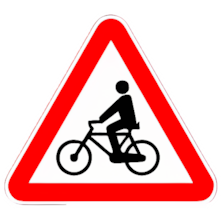
A17 - Cyclists exit
Indication of the proximity of a place frequently used by cyclists who intend to enter or cross the public road. |
|
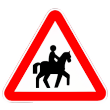
A18 - Knights
Indication of the proximity of a place frequently used by horse riders who intend to enter or cross the public road. |
|
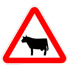
A19A - Animals
Indication of a section of road where animals without a driver may be found. |
|
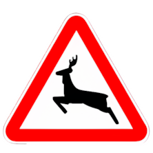
A19B - Wild animals
Indication that the road may be crossed by wild animals. |
|
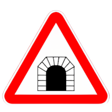
A20 - Tunnel
Indication of the proximity of a tunnel. |
|
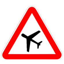
A21 - Airstrip
Indication of the approach to a location where the route may be flown over, at low altitude, by aircraft that have taken off or are about to land on a nearby runway. |
|
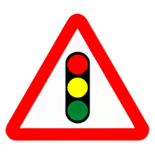
A22 - Light signaling
Indication of the proximity of a place where traffic is regulated by light signals; this signal should only be used in places where drivers are not expected to see that type of signalling. |
|
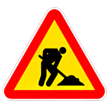
A23 - Road works
Indication of the existence of works or obstacles on the road. |
|
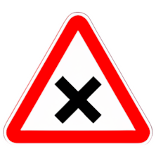
A24 - Crossing or junction
Indication of the proximity of a crossroads or junction where the general rule of priority on the right applies; this sign may only be used exceptionally inside built-up areas. |
|
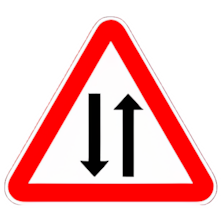
A25 - Two-way traffic
Indication that the road where traffic only moves in one direction now serves traffic in both directions. |
|
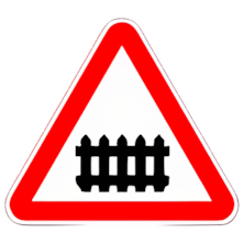
A26 - Level crossing with guard
Indication of the proximity of a level crossing with gates or barriers. |
|
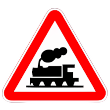
A27 - Unguarded level crossing
Indication of the proximity of a level crossing without gates or barriers, with or without automatic signaling; in addition to this sign, sign A32a or A32b must be placed in the immediate vicinity of the railway track. |
|
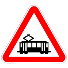
A28 - Intersection with a road where vehicles run on rails
Indication of a crossing or junction with a road where vehicles travel on rails; this sign must not be used at level crossings. |
|
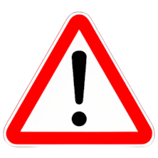
A29 - Other hazards
Indication of a danger different from any of those indicated in the previous signs. |
|
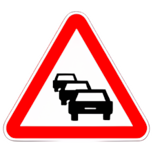
A30 - Congestion
Indication of proximity to a section of road with high traffic volume. |
|
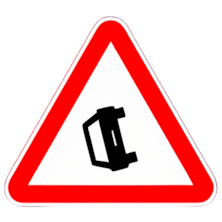
A31 - Obstruction of the road
Indication of the proximity of a section of public road where traffic is obstructed by vehicles. |

|
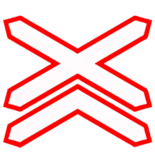
A32A - Unguarded level crossing location
Indication of level crossing location without gates or barriers. |
|
A32B - Unguarded level crossing with two or more tracks
Indication of a level crossing without gates or barriers when there are two or more railway tracks. |
